Isle of Man modeling
back to Examples
A Youtuber by the name of Sleeping Warrior has taken it apon himself to prove that the earth is flat. In doing so he has made many observations of distance objects over water, all of which have demonstrated the curvature of the earth. Here we will discuss a particular observation which was done from a beach at a small town called St. Bees in the UK. This area has a lot of hills and cliffs close to the Irish sea in which there is an island called the Isle of Man. This island has some very distinct features which and a varying land profile which we will explore in this example.
We have downloaded some elevation data from the SRTM mission which covers the entire Isle of Man and we will show how to use this to create a render of that topographical data with refraction:
1 2 3 4 5 6 7 8 9 10 11 12 13 14 15 16 17 18 19 20 21 22 23 24 25 26 27 28 29 30 31 32 33 34 35 36 37 38 39 40 41 42 43 44 45 46 47 48 49 50 51 52 53 54 55 56 57 58 59 60 61 62 63 64 65 66 67 68 69 70 71 72 73 74 75 76 | from refraction_render.renderers import Scene,Renderer_35mm,Renderer_Composite
from refraction_render.calcs import CurveCalc,FlatCalc
from refraction_render.misc import mi_to_m,ft_to_m
from pyproj import Geod
from PIL import Image
import numpy as np
import os
import cProfile
def cfunc(d,h,n_ref,h_max,d_min):
# this is a function which should give the color of the pixels on the
# rendered topographical data. h_max is the maximum value of the elevation
# which for the isle of man is 621 meters, d_min is roughly the minimum distance
# of land away from the observer, which is roughly 50 km.
ng = 100+(255-100)*(d/d_min)**(-4)
nr = ng*(1-h/h_max)
# this line of code is used to generate the shading of the elevation.
# n_ref are a set of unit vector pointing in the direction of the reflected
# ray bounding off of the surface if the lighting is above the object the closer
# the reflected ray is to pointing completly vertical the more illuminated it
# should appear. In this way we can scale the whole rgb color by a dimming factor
# that takes into account this angle. Note we do not take the dimming to 0,
# otherwise the shading would be black.
dimming = 1-0.5*np.abs(n_ref[1,:])
return np.stack(np.broadcast_arrays(dimming*nr,dimming*ng,0),axis=-1)
def T_prof(h):
e1 = np.exp(h/1.5)
e2 = np.exp(h/0.1)
return (2/(1+e1))*0.1+(2/(1+e2))*0.15
# create calculator
calc_args = dict(T0=8.3,P0=103000,T_prof=T_prof)
calc = CurveCalc(**calc_args)
# load topographical data
data = np.array(Image.open("n54_w005_1arc_v3.tif"))
n_lat,n_lon = data.shape
lats = np.linspace(54,55,n_lat) # get latitudes of raster
lons = np.linspace(-5,-4,n_lon) # get longitudes of raster
# data must be flipped row whys so that latitude grid is strictly increasing
data = data[::-1,:].copy()
d_max = mi_to_m(40)
h_obs,lat_obs, lon_obs = 35, 54.487375, -3.599760
h_lighthouse,lat_lighthouse, lon_lighthouse = 43.7, 54.295668, -4.309418
s = Scene()
image_path = "MG_lighthouse_model.png"
s.add_image(image_path,(h_lighthouse,lat_lighthouse,lon_lighthouse),dimensions=(-1,23))
s.add_elevation_model(lats,lons,data)
renderer = Renderer_35mm(calc,h_obs,lat_obs,lon_obs,(lat_lighthouse,lon_lighthouse),
d_max,vert_res=2000,focal_length=2000)
renderer.render_scene(s,'lighthouse_render.png',cfunc=cfunc,cfunc_args=(621,50000),disp=True)
renderer = Renderer_Composite(calc,h_obs,lat_obs,lon_obs,d_max,vert_res=500,focal_length=2000)
heading_min = 235
heading_max = 259
renderer.render_scene(s,"Isle_of_Man_composite.png",heading_min,heading_max,
cfunc=cfunc,cfunc_args=(621,50000),disp=True)
|
Results
Here is a a composite which was composed out of a video panning across the Isle of Man:

Compare this to the rendered version of the composite, here we have tried to guess the correct temperature profile for the inferior mirage.

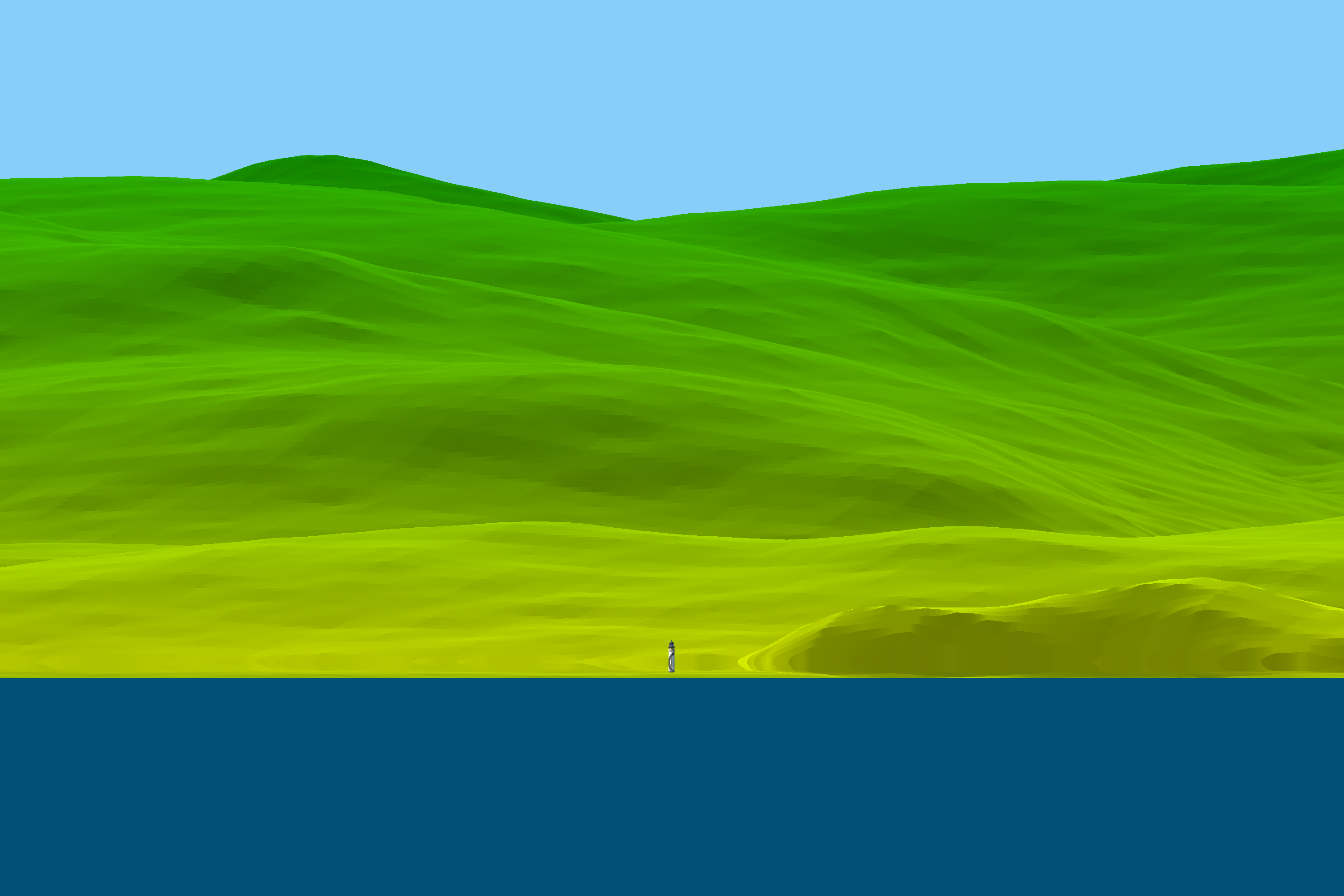
Another interesting thing to look at on the Island is Maughold lighthouse which stimluated much debate as some have argued that it should not be able to be seen from the location where Sleeping Warrior took his video. However we have modeled the lighthouse in its correct position and it turns out that because of the refraction, the light house is actually being very slightly loomed up. Yet another brilliant observation by Mr. Sleeping Warrior proving the Earth is a globe!
back to Examples